Tuesday, October 14, 2014

Mt. Isolation - and Done!

Standing on the summit of Mt Isolation I was torn between getting as many photos as possible, just taking in the view of Mt Washington valley in its fall splendor, and celebrating our completion of hiking all 48 of the NH mountains over 4000 feet. With temps in the 30s and a howling wind it was obvious there wouldn't be much time to do either.  But wow, was it ever beautiful! And we did manage to both enjoy the view and get a few good photos to commemorate the day and the event.


This had been S.D and mys third attempt at sumitting Isolation, the most remote of the 4000fters. The first we had attempted as a day hike and abandoned after only 3.5 miles in the middle of what was an extremely memorable, and even more quotable hissy fit on my part. This time, considering the length of the hike, 14.2 miles, the 11 available hours of sun, and our lack of fitness, along with the desire to do a little backpacking,  we decided to attempt Isolation  as an overnighter. According to the maps and trip reports there was a good tent site less that a mile before the summit that would allow us to hike up, drop our packs, summit and then come back down and spend the night on the mountain. The next morning all we had to do was pack up and hike out.

And that's pretty much how it happened. We hit the trail at 9:00. The first 2 miles are relatively steep and through mixed forest. After that comes a 1.5 or so mile section of what another hiker refers to as "a stream masquerading as a trail".  We tried to locate the "unmissable" T that marks the location of bushwack and missed it.  After crossing the Rock Branch we stopped and ate lunch before continuing North along the river on the old railroad bed for another two or so miles. Then headed due west and up for another mile on another stream masquerading as a trail. At one point we met up with three guys coming down. One of them has just finished the 4000fters! There were congratulations all around and we continued on.  Coming up to the pass the trail wound along the side of a valley and through a quarter mile section of extreme blow downs. Luckily some wonderful trail crew had hiked all the way up here with serious saws and cleared the path. Right after those the trail leveled out in a pine forest, the only level area we'd seen in miles and there was the tent site.

S.D.and I scoped out the site, dropped our gear and headed for the peak. Just after the tent site we hit the Davis Path and turned south.  The Davis path, the first path to the summit of Mt. Washington looked pretty good for a 150 year old trail. After a mile we came to the side trail leading up to the summit. From there is was a short rock scramble to some of the best views in the Whites (of course when is any view in the Whites that is not one of the best?)

Back at the tent site we unpacked, cooked dinner and settled in for cold night. Temperatures dropped into the low 30's but we stayed warm and protected even as the wind blew high over the site. During the night the clouds lifted, the moon brightened the tent, and two flights of Canadian geese honked their way north.

Sunrise was spectacular. Red and orange but in no way foretelling of any bad weather, the day turned sunny and warm.  We packed up and headed down, stopping at the river for a hot oatmeal breakfast.

Feeling a little more relaxed and confident, I agreed to try the bushwack this time. The idea of this is that you get on the 3100ft elevation line and staying on that manage to cut off a mile of the trail and a significant PUDs (pointless ups and downs). S.D did pretty well with the trail blazing and navigation,  I did pretty well with my not-wanting-to-be-lost compulsion,  we got to see a giant moose, and made it back to the official trail alive.

From there it was just a little more rock hopping along the stream/trail, then down the hill and we were back at the trailhead.

Finishing the 4000fter is bittersweet. Some goals you reach and it's good riddance. After months of training you cross the line of a century and you're done. Yea!  Not so much with the 4000fters.  I'm glad to have stood on the summits of all those wonderful mountains.  Having that goal gave us a clear list of spectacular hikes and challenges.  Plus it got us up some very nice peaks that we wouldn't have normally hiked.  The goal of the 4,000 footer club is to get you out on more of the less popular peaks, it worked and it was worth it.  Now were just going to have to find more great hikes on our own.

Saturday, October 04, 2014

See Traverse City by Boat

Schooner Manitou casting off
Mention Traverse City, Michigan to a native New Englander and you get a blank stare. Mention it to a Midwesterner and their eyes light up like you were talking about the land at the end of the rainbow. On the fourth day of our vacation, two New Englanders, who had only experienced Traverse City through the eyes of dreamy Midwesterners  drove into and through that mythic Midwestern town..

After driving up from Bay City through the flat Michigan forest and then along a five mile strip, the quaint two and three story houses and brick business district with wide streets, and the numerous bicyclists and parks along the lake Michigan shore did seem almost magical. Five minutes ago we were in the deep forest two minutes ago the usual, dreary, American strip and then, viola! A cute little town at the foot of a Lake Michigan bay.

Leelanau Peninsula off the bow
As cute as the town was however, we drove on through to a boat two miles up the west side of Grand Traverse Bay. Alyssa was crewing on the Manitou, a schooner that took passengers out for sails on the bay. If we could arrive before 2:00 we could join her for the afternoon tour.

I grew up on the Atlantic coast, in a town near a submarine base. Driving into town was a sign advertising a uniquely Groton experience "See Submarines by Boat!" It was always a curious tourist option in my mind, but it was the phrase that I remembered most.  Seeing Traverse City by boat, was one of those times. It was the best way to get oriented to this new area.


A little town clustered together at the foot of a bay. Gentle hills rolling up from the shores on the east and west, with the expanse of Lake Michigan visible to the north. We had a great sail across the bay and as the excellent crew maned the boat, they and the passengers told us about all the things we needed to do during our three days in town:

Old Mission State Park
1. Walk through town
Sleeping Bear Dunes Lifesaving Station
2. Drink beer. The town has 20 breweries within a five mile radius
3. Drink wine. In the last 20 years the area has developed into an expansive wine region with over 41 vineyards.
S.D.s idea of a grand hotel
4. Marvel at the number of cherry-related items produced. For over one hundred years the area has been a major cherry producer. Apparently there are as many kinds of cherries as there are things you can do with them. Pie is not the only option. There is jam, wine, brandy, grilling sauce, preserves, pit spitting sports, fruit leather and more.
5. Go to Sleeping Bear Dunes State Park (home of the scenic drive and picnic mountain)
6. Get out on the water. Go sailing kayaking,  swimming, and paddle boarding.

And believe it or not, in three days we did all of that!

Tuesday, September 09, 2014

Roadside attractions

It happens at least once one every road trip. That moment of decision where you have to choose between staying on schedule and stopping to see the world's largest cherry pie pan.  Or maybe it's the gravestone of the cow that produced the most milk or the spam (meat) museum. (home to the world's most comprehensive collection of spiced pork artifacts) , but whatever the attraction, it's the outcome of all those little decisions that determine whether or not your road trip is a good trip. 

When it's wet, it's raining!
On this trip, keeping on schedule won out most of the time. Either that or SD and I have to conclude that we are not very good tourists. Even though we passed within three miles of the pie pan, and five miles from the largest cow statue, we didn't stop. According to roadsideamerica.com we sped by hundreds more important attractions.

The Stein Haus
We did however manage to make a few stops.  First was the amazing weather rock located in downtown Foxburg. We also chanced upon an unknown, but lovely tourist destination, Bay City Michigan. Once a rambling lumbertown,  the city fathers (with a little help from Dow Chemical), have created a relaxing Saginaw riverside meca complete with river walk, waterfall park, bicycle lanes, coffee shops and restaurants. We stopped for the night, walked around and enjoyed sauerbraten at the Stein Haus.

Oh to live on Picnic Mountain!
Also in Michigan we chanced upon  the ultimate of American roadside attractions, the Roadside Drive. This is one attraction, courtesy of the National Park system that you can, but don't have to, even get out of your car to enjoy. The Pierce Stocking Scenic Drive at Sleeping Bear Dunes National Park meanders through the coastal plain of the Sleeping Bear Dunes National Lakeshore. Providing pullouts for attractions such as the Glen Lake Overlook, the Dune Overlook and our favorite, Picnic Mountain.  We didn't stop at any but did marvel at how awesome it would be if the National parks started making similar loops for bicycles.

Our trip home was a 14 hour straight shot from Traverse City to Beverly and after being on the road for 7 days we were inclined to drive non-stop. There was however one roadside attraction, one that I had visited several years ago but S.D. had never seen,

The Mother of All Roadside Attractions


that was located tantalizing close to our route. Following a few hours of debate, and a stop at the regional tourist office to get maps we pulled into the parking lot for Niagara Falls around 4:00 in the afternoon.  The crowds were starting to thin out and the sun was just about to fall below tree line. The angle and opportunity were just right. We got to see one of the biggest roadside attractions in the Northeast, just as a double rainbow formed over the falls.


Saturday, August 23, 2014

On the Road Again, and White Knuckling All the Way

The route from Beverly, Ma to Foxburg, Pa. is not the road upon which to end a road-trip hiatus. From MA 128 to I-95 to I-84 to I-81 to I-80 one drives on a primarily two-lane highway paced by enough cars to fill a four-lane highway, all driving at a speed exceeding the speed limit by a minimum of 15 mph. Added to that are numerous construction zones where traffic is funneled down to a single lane, with no shoulders and Jersey barriers brushing against side mirrors.

And yet, that is the road upon which we set out earlish Friday morning of our 8 day road trip. Leaving the house just early enough to squeeze under the Boston morning rush hour we passed Hartford, CT just as their rush hour was in full swing. Of course, after more than a few trips through NYC at rush hour the idea of Hartford's rush hour is just plain silly and provides an amusing diversion. Debating the pros and cons of the commuter lane (which ends 2 miles before reaching downtown), and the haphazard placement of various left exits, we quickly breezed through the capital city.

Somewhere between Hartford, CT and the Danbury, CT we switched drivers, and it was my turn  behind the wheel. Aside from the person in the passenger seat channel surfing at the speed of light, gripping the door handle and slamming his brake foot against the floor, the ride went relatively smoothly until we crossed the Hudson and entered Pennsylvania. While Scranton, PA may conjure visions of Dunder Mifflin for some, for me Scranton, PA evokes Harry Chapin's "Thirty-thousand Pounds of Banana's" and visions for terrifyingly steep hills and curving highways. And that, with the addition of an eternal construction
zone was exactly what I drove through, all the while maintaining a steady 72 MPH, and a blood pressure of 132 over 97.

When we finally reached I-80, it was time for lunch and we soon learned that in between 2007 and 2014, Pilot truck stops and Subway have successfully colonized every single exit from Drum to Foxbuurg

. This is good news for those wanting a relatively healthy fast food lunch, not so good for someone wanting to rationalize the necessity of a peanut M & M and diet coke lunch.

Back on the road, again, the miles seemed to go by slower every hour as the constructions zones, and tandem truck convoys became more frequent. For what was supposed to be an eight hour drive, this was beginning to feel like a never-ending endurance contest. And I was not winning. Finally, and only after giving up all hope, the Foxburg exit appeared. We left the highway and coasted down a long country road into an amazingly tidy, compact town on the Allegheny River. Our Inn, sited on the shore of the river and across from a Chocolatier and Wine Shop, looked just perfect. 


Tuesday, August 19, 2014

Road Trip: Return of the road warrior?

There was a time when I'd easily drive to Michigan and back for the weekend. A time when 14 hours behind the wheel was like a trip to the corner grocery store. My road food of choice was peanut m & m's (for the protein) and diet coke (so I didn't gain a lot of weight for all the sitting and peanut m & m's). Highs and low of the journey included roadside stops and channel surfing. Sometimes there would be a great town, sometimes they were downright scary, sometimes you'd get a stretch of great tunes and sometimes, the radio too could be a bit scary.

But times change. The airplane was invented, the bicycle became a better option for around town, the train for going to work. I sold the car and started flying to adventures. The change expanded the range but also changed the nature of the adventure.  Peanut m & m's were replaced by Starbucks salads (and who can say which is the best nutritional choice.), layovers were highly researched and rarely surprising, music was pre-loaded on my phone, and never, ever, could there be any sing-alongs.

This week, however I return to the road. In one of those unusual circumstances where the necessary destinations / airport locations / travel time configurations lends itself not to flying but rather to road tripping. Over the course of 7 days we'll drive a minimum of 31 hours. Stopping along the way at places known and unknown. Visiting family, seeing new sights, grimacing at gas station rest rooms, drinking new craft beers, peanut eating m and m's and cranking up the tunes as we roll west to Pennsylvania and then on to Michigan, and home by way of Canada and Niagara falls.

It's been 10 years since the last trip. I do hope it's as fun as I remember.

Sunday, July 20, 2014

The Bee as Metaphor

Often, when walking by the hive, I find myself inadvertently reciting  Issac Watt's classic divine and moral song for children. 

----
How doth the little busy Bee
   Improve each shining Hour,
And gather Honey all the day
   From every opening Flower!*

-------

 It's not a top twenty hit but it does go a long way to describing bees.  They are busy all the time! Busy as bees, as the metaphor states. Bees, in face, are the object of many metaphors.

Take the Worker Bee. She is both a capitalist and a communist metaphor for the perfect worker. They are up first thing in the morning. No burning daylight for a bee. When the dawn is slow, or a bit chilly they will crowd up on the hive board, just inside, waiting for the second the temperature shifts to flying weather.

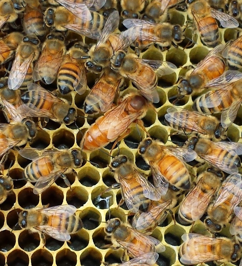
The collective minding the queen
Once the worker bees start flying for the day, it's a constant stream of nectar and pollen gatherers out and back. These days when there are so many bees, the traffic gets too heavy and there's whirling back up just before the entrance. They are born working, and they die working. Admittedly they get a lot done, but they only get enough of the 'profit' to keep them alive through the winter.

And then there is the drone, or male bee.  While there are no current metaphors for the bee who's only purpose is to have sex with the queen and die, there are a number of related meanings.  In the 16th century drone was given the figurative sense of 'idler' or 'lazy worker', as male bees make no honey. In our time drone is most commonly used as the name of an unmanned aerial vehicle. It's a connection that is unclear. Not sure how one gets from the idea of a male bee flying around looking for sex to a brainless piece of equipment. .. oh I think I get it now.

Don't want to be a Royal
The most popular bee metaphor however is that of the  queen bee. But unlike the others' it doesn't reflect real bee behavior.  A human 'queen bee'  is a woman who is the "leader of the pack, an extremely confident woman who's biggest fault may be she is too extremely confident." A true queen bee spends her life laying eggs under the watchful eyes of the worker bees. She gets one "maiden flight' during which she is promptly and repeatedly 'unmaidened' by the otherwise superfluous drones, and then it's back to the hive for a life of egg laying...until the workers bees decide she is unsuitable and kill her. If you are ever compared to a queen bee, watch your back. 

The most unflattering metaphor that relies upon the functioning of whole hive is that of the Borg. A collection of species that have been turned into cybernetic organisms functioning as drones of the Collective, or the hive.  Resistance to joining the Borg is futile, and while there is a Borg queen, they do not do anything useful like pollinate flowers produce anything as wonderful as honey. Upon that premise, I think the metaphor should be disallowed.

The good news is the Hive is also the foundation of many good metaphors and has been co-opted by artist co-operatives, farming co-ops,states (Utah) and even bike shops to symbolize a collaborative group of individuals working for the common good. 

But really, they're just bees, and all the metaphors are human projections on an insect with an elaborate social survival strategy...that is fun to watch.


 *Against Idleness and Mischief

Thursday, July 03, 2014

Public Service Annoucement for Walkers, Runners and Bicyclists

With the Holiday weekend approaching and the summer vacation season upon us I'd like to take a break from the regular adventure posts to highlight ways NOT to be adventurous. In other words, walk, run and bike safely!

Really it's very simple.

Walkers and runners:
1. Walk and run on the sidewalk where available
2. If there is no sidewalk, walk and run facing traffic, on the left side of the road

Bicyclists:
1. Ride in the road. Riding on the sidewalk is dangerous because sidewalk site lines were not set up with bicycle speeds in mind
2. Ride with traffic, on the right side of the road.


The consequences of doing it wrong are serious, and the danger so obvious, and the obliviousness to the danger so flagrant that I am tempted to post one or more of the following signs, or pass out flyers. Not sure which would be more effective/obnoxious.Votes, comments and suggestions are appreciated.