Thursday, December 16, 2010

The Chateau


What with New England winter upon us, the weather getting colder, the days shorter and the opportunities for peak bagging limited, we decided it was time to make some changes to our weekend routine. What we needed was somewhere warm to go. Somewhere the old folks that we are becoming could luxuriate in comfort. Somewhere with a big fluffy bed to spend the night and a pot of tea and a croissant would great us in the morning. And so we bought a Chateau.


A 1981 Ford Chateau Van that is. V6, manual transmission with only 117,000 miles, but most importantly - a dining table/bed, sink with running water, a real stove (from which you can lay in bed and boil water), a heater for those really cold New Hampshire mornings, .a port-a-potty in it's own tiny room, and storage for backpacks, snowshoes, skis et al. Ah – the luxury! Our own little ABC (Advanced Base Camp) on wheels.

ps - If anyone is interested in purchasing a 2004 Pontiac Vibe with only 87,000 miles - Let me know.

Friday, December 03, 2010

And then there were 10!

Only ten more of the New Hampshire 4000fter's to climb!

Carter Dome, Wildcat, Wildcat D, Moriah, Jefferson, Isolation, Owl's Head, Lincoln, Liberty and Flume.

Unfortunately each one is a little problematic - especially as winter approaches. Carter, the Wildcats, Jefferson, Lincoln, Liberty and Flume are notoriously icy. Owl's Head and Isolation are, well, isolated. A long walk under clear skies and long days, a trek in snow shoes and headlamps. And then, way up North in Gorham, is Moriah.

The big plan is to finish by my 50th birthday, and that is certainly doable, but we're on a roll, we're in shape now!  I don't want to stop but going on may require some type of change in strategy-just not sure what/how.

Tuesday, November 30, 2010

The Tripyramids: When is a trail not a trail?


...when it's a rock slide. 

It was Thanksgiving Day morning and I was plastered to the side of North Tripyramid. Sure I'd read the guide book carefully noting that the trail climbed up a rock slide, covered 1200ft in .5 miles and was "difficult and dangerous in wet or icy conditions" where "ice may form early in fall" . And yes I certainly knew I had problems with heights. But still, there I was half way up a trail that was really a vertical rock slab and very close to freaking out. S.D was urging me to admire the view, all I could look at was the ice-covered granite 6 inches from my nose.

It took a while, some careful guiding by S.D. and many small steps but eventually we reached the cairn at the top and gratefully plunged back into the safety of the pines.
The rest of the hike was nice. We enjoyed a peanut butter and jelly sandwich Thanksgiving feast on the North summit, then hiked along the ridge to the Middle and South summits.  Descending via the loosely graveled South slide was anti-climatic, and I thoroughly enjoyed the view to the South, over the lakes region.We completed the 11 mile loop in good time and went home to cross two more of the 4000fters off the list.

Sunday, November 28, 2010

Mt. Moosilauke: The 4000fters and the gearheads who climb them in snow


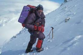
It was a sunny, warm, 50 degree day back in Manchester, MA. At least that what my friends tell me. It's a little hard to believe considering that we less than 140 miles North, 4800ft. higher and in a blizzard.We were on the summit of Mt. Moosilauke, wearing every piece of clothing we had (and still cold), leaning into the 40 knot wind (and still getting knocked down).

There were no views, except of rhyme ice-covered, unreadable signs and the stone wall remnants from the Prospect/Tip-Top House, a popular Victorian-era summit motel but we were very happy to be there. As were the two other guys who summitted at the same time and the 8 other people we met on the way down.

It takes a special kind of hiker to be out in bad weather, climbing bald mountains on view-less days. I imagine we all shared the love of the outdoors, the challenge of the climb and a bit of obsessiveness. However, we didn't (and often don't), share an idea of what type of gear was required, and winter climbing seems to bring out a breed of gear-obsessive hikers that we'd not experienced before. With our down sweaters, techwick underwear, fleece gloves, wool hats, hiking boots we felt plenty warm. For gear we had our hiking poles, and if the trail had proved icy enough, (which it didn't) we also had microspikes. If we'd been delayed until dark we had headlamps. The idea being to carry a little more than you need but not so much that you weigh/slow yourself down.

The guys we summitted with shared our philosophy. They traveled fast (actually overtaking us 200 ft below the peak), dressed warmly and carried moderate-sized packs that presumably held the few items necessary for more extreme conditions.

The hikers we met while descending (they still heading for the exposed summit) all seemed of a different breed. The first couple, whom we met on the old Carriage Road trail between South peak and the summit, were struggling upwards with large backpacks and wearing their microspikes.  Microspikes are great for walking on ice, but there were only scattered patches of ice on the trail, and less than an inch of snow. We assumed that they assumed the summit was icer but when we told them the summit was icy but the trail was snow, they gave us a dismissive hand wave and trudged on.

Further down the Carriage Road (and trails named Carriage Road are wide, relatively flat, and once were traveled by horse and carriage) we came around a bend to find a lone woman standing in the middle of the trail. From a distance her enormous backpack was obvious, from closer it was clear that she was dressed for a full alpine assault. Snow parka and pants, over gloves, full gaiters and microspikes. Just as I came close enough to say hi, her hiking partner came around the bend.  The guy was seriously out of breath and just as seriously outfitted.  Assuming from the size of their packs that they had overnight gear I asked where they were headed. They looked at me like I had two heads. They were only going to the summit! The guy looked at our gear, obviously noting the daypacks, the lack of gaiters and the bare, microspikeless boots and commented that "at least we weren't wearing cotton pants" caught his breath and laboriously headed up the Road. Later S.D. told me the he saw an ice axe strapped to the guy's pack.

For the rest of the descent I couldn't help but notice their tracks, the distinct double-diamond impressions made by microspikes, as they wore them for 3 miles over ice-less, slightly snowy trail and wonder why? Why gaiters when there was no snow? Why micospikes when there was no ice? Why an ice axe when there was, and never would be, a reason for an ice axe on this trail? And what could have possibly been in those enormous packs?

Sunday, November 21, 2010

Mt Osceola, and East Osceola: The Perfect Yoga Spot

Back in North Stonington, on the Connecticut/Rhode Island border, there is a trail to a high, large flat rock. Often I'd hike out that way and stop to practice yoga. While hiking all over New England I come across other inspirational spots. Open expansive areas that seem just perfect for sun salutations, tree poses, or a flow through the warrior posses. Often, while doing yoga videos I wonder why they choose to shoot in a stale empty room when they could have filmed out here, in the woods, grounding to the earth through a giant granite outcropping ribbed with quartz as opposed to cold, dull concrete.
But last Friday, I was thinking of none of that. It was sunny, warm and the sky was a deep blue. We started off from the Tripoli Rd. trailhead at 7:30 (just the time I'd usually be arriving at North Station) and quickly began climbing the 3.2 mile, 2300' elevation gain to the summit of Mt. Osceola. It's a great hike. There are plenty of views off to the East and while I did slide once crossing the ice on the rock faces above 3000ft the trail was pretty easy going. We arrived at the summit in a little over 2 hours.

And there on the summit, actually just a little below and to the North of the summit is a big, flat granite expanse open to splendid views to the East. A 180 degree panorama of forested peaks, deep green valleys, bald, glittering lakes and snow covered mountains. All beneath the clearest of blue skies - is The Perfect Yoga Spot. It's a setting that Rodney Yee's Hawaiian landscapes will never come close to matching.

We marveled for a few minutes then continued on the trail to East Osceola, another peak, a mile away over a much different, more challenging trail that included the infamous 'chimney' (a vertical 300 ft. climb/drop). East Osceola's summit was marked by a small cairn in the woods at which point we turned around and headed back to Osceola where we ate lunch and did a little yoga. Namaste.

Monday, November 01, 2010

Now that's an erratic

 It wasn't so much the snow blowing by at 30 mph as it was the ice hanging off the rock face that was intimidating. That, and the fact that if you were inclined to follow the yellow blazes that marked the trail, the realization that the icy rock face was the trail.

For the first 1.5 miles the trail climbed the 2000 ft to Glenn Boulder through forests of tall broad Beech and Hemlock. The snow falling gently, sticking only to the fallen leaves and dark green needles. But that all changed abruptly when we popped out above the treeline. And by abruptly I mean one step. A step up onto the rocks and the wind almost knocked you over as the snow bit into your face. A step back and it was once again a calm, gentle flurry. A step up and the snow fell on the rocks and melted to an icy sheen, a step down and it melted away.

The plan for the day was to hike the Glen Boulder trail to the Davis Trail, then go south, summit Mt. Isolation and head back. A 12 mile round trip that promised good hiking with over two miles of splendid views above treeline. The weather however, changed all that. With blowing snow, there would be no splendid views, and the time above treeline would be more than we'd planned for when setting out on a late fall hike.

So we hiked up to Glen Boulder, marveled at the snow building over the ridge from the direction of Mount Washington, took a few photos, debated the need for the microspikes, and headed down. I might be game for winter hiking, but I'm not quite ready for icy blizzard hiking.

Thursday, October 14, 2010

Three-fer: North and South Kinsman and Cannon

There are times when a slideshow is better than 1,000,000,000 words. This slideshow follows us up to Lonesome Lake, Kinsman Pond, North then South Kinsman. After that we camped at Kinsman Pond, leaving early in the morning to pop over the infamous Cannonballs, summit Cannon Mountain, and return via Lonesome Lake.

Monday, October 04, 2010

Passaconaway, Carrigain and thoughts on Winter Hiking

 This last weekend we hiked Carrigain and the weekend before we did Passaconaway – that makes two weekends in a row that were just phenomenally perfect! The weather on both days was clear, the views spectacular. The leaves are at peak color and every view you have is better than the rest. Every corner you turn, the trail just looks more fantastic. This being New England however, the temperatures between the two weekends were radically different. Two weeks ago it was 75 degrees this week, 45. While we ate lunch in our t-shirts and shorts on Passaconaway we retreated from the rime-ice covered Carrigain summit to have lunch huddled behind some stunted firs on Signal Ridge. Wearing our fleeces and soft shells it was still way too cold. But we enjoyed watching the high clouds flying over the Presidential range and occasionally glimpsed Mt. Washington.

This weekend was the first time I've ever seen rime ice. It coated everything on the North side of Carrigain's summit and really made me think twice about winter summiting. We'd started our climb in shorts and long sleeve t-shirts but here at only 4700 ft it was cold enough to make ice. Imagine how cold it would be on top if is was snowing below. Image how cold it was at the top of Mt Washington only 50 miles North and 2000 feet higher. Image how much you'd have to carry in your pack to cover the possibilities! There are dead bodies all over Mt. Everest. I'd been reading about some of them in The Lost Explorer and other mountaineering books and the reason for it is often because they were not prepared for the mountain. While you probably won't stumble upon any dead bodies in the Whites, you will stumble across lots of unprepared hikers, and unless you carry a lot of extra gear – you could easily be one of those very hikers/bodies. Alarmist, but true – read Not Without Peril.

But – its so good to be hiking, and now that the Whites are in my backyard, I can't imagine not going for an entire season. It's time to gear up for winter hiking!

Thursday, September 16, 2010

The Screen Room and Mosquito Batting

Thursday morning, the rain continued. We took a hike in the morning hoping things would clear, we even checked out the "oldest covered bridge in the United States",  but by afternoon it was still raining. And it was cold.
When car camping we take what is referred to as "The Palace" - a six person LL Bean dome tent that fits a blow up full sized mattress with room to spare, and the LL Bean Woodland Screen Room. Up until camping at Glimmerglass I'd not been an enthusiastic supporter of the Screen Room but sitting inside on Thursday afternoon as the mosquitoes buzzed around outside I was appreciating the finer points of micromesh netting. As the evening came on, more mosquitoes came out, boredom set in. It was at this point, while holding my hand within 1/2 inch of the screen just to watch the frantic mosquitoes try to get through to all that luscious blood I wondered what tomorrow's forecast was. Another day like this and who knows what I'd be doing.

Wednesday, September 15, 2010

Lake Otsego and Ommegang Brewery

Wednesday morning we headed south from the campground to Cooperstown and Stagecoach coffee. There wasn't a shoulder on Rt 31, but there weren't many cars so the ride was good. The coffee was excellent! After our little caffeine kick we cranked up the West shore enjoying the scenery and the addition of shoulders to the road. There was one giant hill at the end of the loop which I had to shift into granny gear to climb - but I did climb it! and flew down the other side into Glimmerglass State Park just as the rain started.

In the afternoon we sort of solved the mystery of why the Ommegang Brewery, The Best Brewer of Belgian Beer in America was located in Cooperstown, or at least after the beer tasting we really didn't care. Apparently the area was, in the 1800's, the biggest producer of hops in America. They don't grow it there now, they just make the beer and give tours of the brewery. It was a good tour, our tour guide was very informative and although I could not convince them to start making Triple Perfection again, I did like the Witte, Rarevos. Driving back to the tent, in the rain, I felt all warm and fuzzy inside.

Tuesday, September 14, 2010

Cooperstown

Cooperstown, the town named for one family and run by another. Aside from the Main Street tourist trade, baseball really has very little to do with it. Founded by, or rather owned by James Fenimore Cooper's father, William Cooper's Town: Power and Persuasion on the Frontier of the Early American Republic is a good book that goes into the details both about the father and the son's involvement with the town. Then along about the 1880s came the Clarks. Not content with running the Singer Sewing Machine Company, and the Dakota as well as founding the Met and a number of other significant museums the The Clarks of Cooperstown have run their little vacation town for four successive generations.

It is a sweet little town, close to perfect, nestled on the South Shore of Otsego Lake. We set up camp at Glimmerglass State Park and made plans for a ride around the Lake on Wednesday. Our guide this time was Cranks from Cooperstown: 50 Bike Rides in Upstate New York, a very thorough guidebook to the area, and my daughter.

We had dinner at a dockside restaurant, admiring the Lake and what Amy felt was truly unusual, a lovely, cloud free evening.

Monday, September 13, 2010

Bon Bon Alternative*

Riding into a 30 knot headwind on the shoulder of road with giant RVs speeding by at 55 mph I again, had to wonder – why? I could be siting in a safe, air conditioned little cocoon, in front of a TV, eating Bon Bons. I do know people who love that, who live for that. Who work all week just so they can do that very thing. It is the antithesis of my idea of life and thinking about it, I pedal faster, drafting a bit off the next passing RV.

We ended up riding a 36 mile circumnavigation of Grand Isle, VT, After braving the traffic of RT 2 we swung North on side roads stopping along the way to check out the volunteer-run bike-ferry between Grand Isle and Burlington, sampling homemade donuts, watching a para-sailer, touring the fish hatchery and enjoying the phenomenal scenery. From the west shore of Grand Isle you look into New York and Adirondack Mountains, on the east side, the ridge from Mt. Mansfield to Camel's Hump stretches North to South.

It was a great ride for the end of this first half of the vacation. Tomorrow we head to Cooperstown for Part II. The Bon Bons will have to wait.

*Not to be confused with the Bon Ton Roulet.

Sunday, September 12, 2010

French Canadians and State Parks

The following day, the Saturday of Labor Day weekend we headed out for a 50 miler. Luckily we had done the 20 before or I don't think we'd have made it. Most of the route we'd ridden last year. North to Hero's Welcome where we stopped for coffee (and a chocolate croissant). Out at the picnic area we met a Quebec couple who were just finishing a 14 day bike circumnavigation of Lake Champlain. One of them rode a Rocky Mountain Sherpa, the bike I'd had for the Holland trip. Twelve miles North of there we stopped at North Hero State Park and talked to a cyclist from Montreal.

Heading west, with an eye on the building storm clouds, we crossed over a bridge were some kids were jumping off into the water. They'd even strung up a rope swing underneath, and were having a great time. Our next stop was Sand Dunes State Park. Ummm. Well, all I can say is coming from the Atlantic Coast, and having seen Pink Sand Dunes National Park in Utah, I guess I expect a bit more sand in my Sand Dunes. But Vermont seemed very proud of their sand. After all it had been deposited by the glacier thousands of years ago, and while the rest of the entire shore of Lake Champlain consists of tiny shale stones, here on the south tip of Alberg, there is indeed, Sand. Here again were two guys from Canada. The Ranger was American but he was the only other soul on the beach.

Heading home, and pretty hungry by now, we stopped again at Hero's Welcome (they have great sandwiches!), and watched a whole peloton of French Canadian touring cyclists gather. A few Americans stopped by too, but the crowd was predominately French speaking.

So many Canadians touring, so few Americans. Even if we were only 20 miles from Canada – it still seemed a bit out of balance. It also, perhaps goes a bit further to explain why, when Amy and I rode our bikes around Belgium 5 years ago, the Belgians insisted we were Canadian. “Canada?” “Non, Etats Unis”. “Noooo, Canada!”

Saturday, September 11, 2010

End of the Hiatus – Return to Grand Isle

After 3 week out of the saddle being back “in” felt good. Especially going downhill and downwind along the East Shore of Grand Isle, Vermont. Turning West into the wind, nine miles later things began to slow down and when we headed uphill – I probably could have walked faster.

But is was good to be back on the bike, and back in Grand Isle where we spent 3 days biking last year, and planned to spend another 4 this time. The main roads have nice shoulders and while the back roads don't, the drivers pull over, and there are honor system fruit stands with “Welcome Cyclists” signs.

As with last year we relied upon the Charles Hansen book - which is great at directions and also at pointing out the sights. According to him the ride around North Hero/Grand Isle is the best one in all the Lake Champlain region, and after our ride on Monday, I have to believe him.

Wednesday, August 18, 2010

Everest and K2 (books about)

Ed Viesters has a saying, *Getting up the mountain is optional, getting down is mandatory'. My Himalaya's quote is not so dramatic, “It's not just about having a great book to read on the train, its also about making sure not to cry every time someone summits or dies" (both of which happen with great regularity).

During my own peak bagging lull, while we're bike riding on weekends in preparation for a week's cycling vacation in Vermont and Northern New York, I've been climbing The Big Ones (mountains over 8000 meters) vicariously. It all started innocently enough when a friend recommended Last of His Kind, the biography of Bradford Washburn, the past director of the Boston Museum of Science, and lifelong climber of Alaskan Mountains.

Next someone lent me Edmund Hillary's account of his 1953 ascent of Mount Everett, View from the Summit: The Remarkable Memoir by the First Person to Conquer Everest. That then inspired me to reread Touching my fathers soul, a book by Tenzing's son who was part of the 1996 IMAX team. I'd read this book a few years ago as it talks a great deal about the Sherpa's, their climbing and culture. Then came Tom Hornbein's Everest: The West Ridge. Which tells not only how Tom Hornbein and Willi Unsoeld climbed Everest via the West Ridge route but also contains great quotes about mountaineering by the great mountaineers.

Then somehow I start 'climbing' K2. The second highest, and some say deadliest mountain. First there was K2: the savage mountain which is about the 1953 expedition. While one of the team members did die, it really is, as all the other mountaineers in the other books say, a book about the 'brotherhood' of climbers. The culture that makes for a great climb, instead of just a summit. K2: Life and Death on the Worlds Most Dangerous Mountain, details all the climbing attempts on the mountain.

And then came Ed Viesturs. The name had come up repeatedly in the other books. Apparently he was this guy who had decided to climb all 14 peaks above 8000 meters, without oxygen. He was with Jamling Norgay during the 1996 climb of Everest (his first summit of Everest without oxygen), he climbed K2 in 1993, and finished his quest in 2008 with Annapurna. I'd read somewhere that he had, with the assistance of David Roberts, written a book/autobiography. No shortcuts to the top is great! It is an honest look at an honest and really competent guy. Sometimes you wonder if he doesn't think a little too highly of himself, but then you realize, he's just relating the facts. It's the facts that speak highly of him. And he has a sense of humor. (Here's a clip of him on The Colbert Report)

It is said that books open up new worlds. Reading these mountaineering books I've not only seen worlds I'd never see in person, I've become slightly conversant in them, the people who have lived and died in them, the culture that is there, that congregates around the mountain,

And now, not only can I pretend to be in the Tour de France when I ride my bike, I can also pretend to be summitting K2, without oxygen, in 50 mph winds while hiking in the White Mountains.

Wednesday, July 28, 2010

Tecumseh: The Western Approach

Just because it's the shortest 4000fter doesn't mean you have to take the shortest path to the top. At 4003ft, the peak of Mt. Tecumseh is accessible via two routes. One up the ski slopes of Waterville Valley is the shortest but the Western Approach (which sounds much more impressively technical) is the nicer.

Starting form Tripoli Road, a unique combination of fire road/campground, the trail crosses two brooks then begins a gentle ascent along an old road. One guide book called it a logging road, but another book, Logging railroads of the Saco River Valley, suggested it might have originally been a farm road. Now days, it is a nice wide path through a mature forest of maples, oaks, and gray and white birches. While the area was last farmed/logged in the 1910's it apparently never suffered through the devastating fires that set back forest reclamation in other areas of the White Mountains. Still the trees are so big, it's hard to believe that some of these large trees are only a hundred years old.

After about .5 miles the trail takes a right hand turn off the old road and begins ascending at a steeper pitch just as a few conifers begin to appear in the forest. Occasionally clearings offer views North to Mt. Osceola or turns in the trail bring you face to face with a fox. We saw this guy twice, once on the way up, and again on the way down. Tom, the only other person we met on the trail had seen the fox too, said it even walked in front of him for a little while. When we first 'met' Mr. Fox, he just sat in the middle of the trail and looked at us. Very calmly. The second time he had a chipmunk and only a few seconds for us. It was obvious from his demeanor and the many little paw prints in the muddy sections of the trail, that this was his hunting ground and that he was very comfortable with people. Not sure exactly, however, we fit into his plans.

The rest of the walk was very nice, the trail wide, and the view from the top was off to the North and the  Tripyramids. On the way down we hiked through a great thunderstorm. They really are so much more enjoyable when you've got a warm car and a dry change of cloths at the end of the trail! 

Wednesday, July 14, 2010

Miles from Nowhere - Bicycle Touring

Miles From Nowhere is one of the best bicycling touring books ever! Joe Kurmaskie's Metal Cowboy: Tales from the Road Less Pedaled and Riding Outside The Lines: International Incidents and Other Misadventures with the Metal Cowboy are great fun, but they don't come close to describing the day – to – day hunting and gathering- all-the-while-dealing-with-new-cultures aspect that Barbara Savage manages to brings out during her and her husband Larry's two year ride around the world.

Today's world is remarkably different than the late 1970's when the Savages took their ride and you can't help wondering how it would play out today. Certainly they wouldn't need to go months without hearing from home, or pedal furiously over dirt roads to be in town for a wire-transfer, scheduled 6 months previous and we know that the wind still blows furiously in South Dakota and Austria, the Himilayans still have very high passes, India is hot and dry, and New Zealand is still populated predominantly by sheep but the bigger questions remain. Do drivers in the Florida Keys still run bicycles off the road? Can bicyclists still camp at Stonehedge? Do Egyptians continue to stare at foreigners, or just foreigners on bikes? Will New Zealanders loan you their car to tour the island? Can you still camp on the beaches in Tahti?

Hmmm, maybe I'll have to take a ride and find out.